Contains one row for every row in QUAD_DATA.
This view is useful for querying and maintaining the QUAD_DATA table when it is convenient to have X and Y coordinates as separate values instead of geospatial points.
Figure 6.153. Query Defining the QUADS View
SELECT quad_data.quad AS quad

     , ST_X(quad_data.xyloc) AS x

     , ST_Y(quad_data.xyloc) AS y

     , quad_data.aerial AS aerial

  FROM quad_data
;
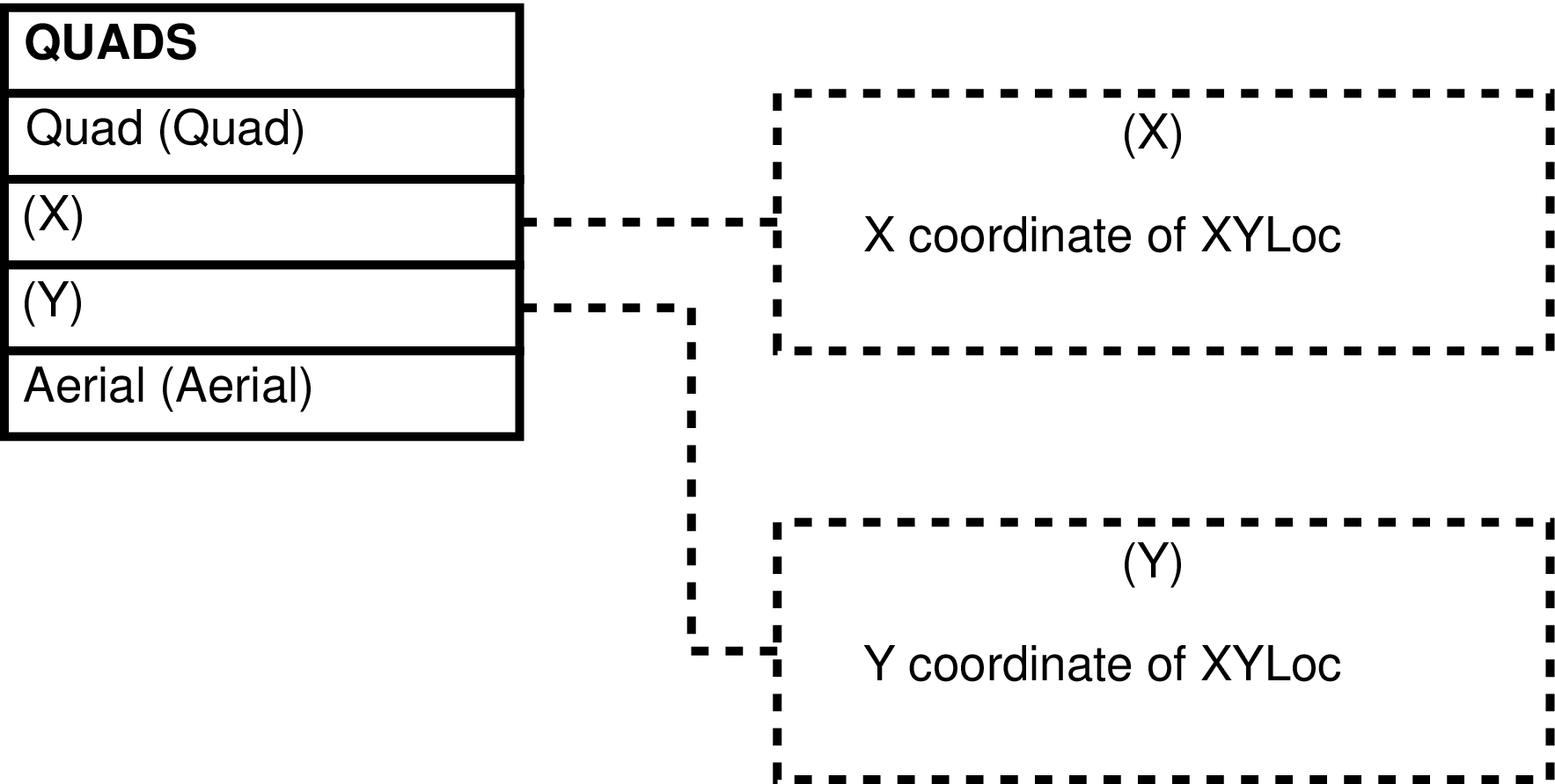
Table 6.73. Columns in the QUADS View
| Column | From | Description |
|---|---|---|
| Quad | QUAD_DATA.Quad | Identifier of the map quadrant. |
| X | ST_X(QUAD_DATA.XYLoc) | X coordinate of the XYLoc -- X coordinate of the centroid of the map quadrant. |
| Y | ST_Y(QUAD_DATA.XYLoc) | Y coordinate of the XYLoc -- Y coordinate of the centroid of the map quadrant. |
| Aerial | AERIALS.Aerial | Code indicating the aerial photo in which the map quadrant is located. |
Contains one row for every row in SWERB_DATA.
This view is useful for querying the SWERB_DATA table because it unifies data that is distributed throughout the various SWERB tables. It is also useful when it is convenient to have X and Y or longitude and latitude coordinates as separate values instead of geospatial points.
Note
For more information on the X and Y coordinates see the description of the columns in the underlying tables, see the SWERB Data overview, and see the Amboseli Baboon Research Project Monitoring Guide.
Figure 6.155. Query Defining the SWERB View
SELECT swerb_data.swid AS swid

     , swerb_departs_data.did AS did

     , swerb_departs_data.date AS date

     , swerb_data.time AS time

     , swerb_bes.beid AS beid

     , swerb_bes.focal_grp AS focal_grp

     , swerb_bes.seq AS seq

     , swerb_data.event AS event

     , swerb_data.seen_grp AS seen_grp

     , swerb_data.lone_animal AS lone_animal

     , swerb_data.quad AS quad

     , CASE

         WHEN swerb_data.quad IS NOT NULL

           THEN 'quad'

         WHEN swerb_data.xyloc IS NULL

           THEN 'n/a'

         ELSE 'gps'

       END AS xysource

     , COALESCE(ST_X(swerb_data.xyloc), ST_X(quad_data.xyloc))

         AS x

     , COALESCE(ST_Y(swerb_data.xyloc), ST_Y(quad_data.xyloc))

         AS y

     , COALESCE(ST_X(ST_TRANSFORM(swerb_data.xyloc, 4326))

              , ST_X(ST_TRANSFORM(quad_data.xyloc, 4326)))

         AS long

     , COALESCE(ST_Y(ST_TRANSFORM(swerb_data.xyloc, 4326))

              , ST_Y(ST_TRANSFORM(quad_data.xyloc, 4326)))

         AS lat

     , swerb_data.altitude AS altitude

     , swerb_data.pdop AS pdop

     , swerb_data.accuracy AS accuracy

     , swerb_data.subgroup AS subgroup

     , swerb_data.ogdistance AS ogdistance

     , swerb_data.gps_datetime AS gps_datetime

     , swerb_data.garmincode AS garmincode

     , swerb_data.predator AS predator

     , swerb_loc_data.loc AS loc

     , swerb_loc_data.adcode AS adcode

     , adcodes.adn AS adn

     , swerb_loc_data.loc_status AS loc_status

     , swerb_loc_data.adtime AS adtime

     , ST_X(swerb_loc_gps.xyloc) AS second_x

     , ST_Y(swerb_loc_gps.xyloc) AS second_y

     , ST_X(ST_TRANSFORM(swerb_loc_gps.xyloc, 4326)) AS second_long

     , ST_Y(ST_TRANSFORM(swerb_loc_gps.xyloc, 4326)) AS second_lat

     , swerb_loc_gps.altitude AS second_altitude

     , swerb_loc_gps.pdop AS second_pdop

     , swerb_loc_gps.accuracy AS second_accuracy

     , swerb_loc_gps.gps_datetime AS second_gps_datetime

     , swerb_loc_gps.garmincode AS second_garmincode

     , swerb_bes.start AS start

     , swerb_bes.btimeest AS btimeest

     , swerb_bes.bsource AS bsource

     , swerb_bes.stop AS stop

     , swerb_bes.etimeest AS etimeest

     , swerb_bes.esource AS esource

     , swerb_bes.is_effort AS is_effort

     , swerb_departs_gps.gps AS gps

     , swerb_bes.notes AS notes

  FROM swerb_data

       LEFT OUTER JOIN quad_data

                       ON (quad_data.quad = swerb_data.quad)

       JOIN swerb_bes

            ON (swerb_bes.beid = swerb_data.beid)

       JOIN swerb_departs_data

            ON (swerb_departs_data.did = swerb_bes.did)

       LEFT OUTER JOIN swerb_departs_gps

                       ON (swerb_departs_gps.did = swerb_bes.did)

       LEFT OUTER JOIN swerb_loc_data

                       ON (swerb_loc_data.swid = swerb_data.swid)

       LEFT OUTER JOIN adcodes ON (adcodes.adcode = swerb_loc_data.adcode)

       LEFT OUTER JOIN swerb_loc_gps

                       ON (swerb_loc_gps.swid = swerb_loc_data.swid)
;
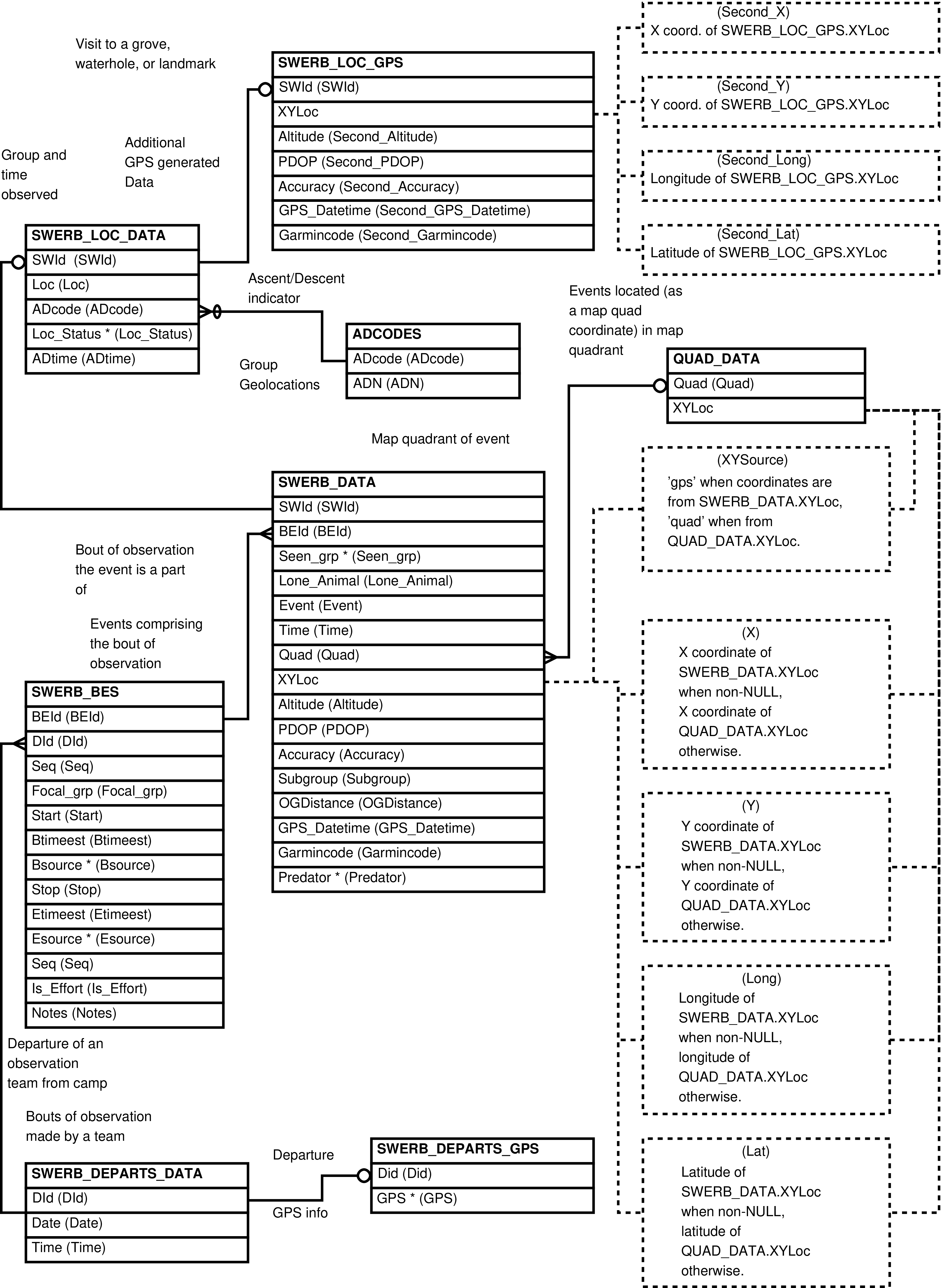
Table 6.74. Columns in the SWERB View
| Column | From | Description |
|---|---|---|
| SWId | SWERB_DATA.SWId | Identifier of the record of the SWERB event. |
| DId | SWERB_DEPARTS_DATA.DId | Identifier of the record of departure from camp of the observation team which recorded the SWERB event. |
| Date | SWERB_DEPARTS_DATA.Date | The date of the observation. |
| Time | SWERB_DATA.Time | The time of the observation. |
| BEId | SWERB_BES.BEId | Identifier of the bout of uninterrupted observation of the focal group containing observed SWERB event. |
| Focal_grp | SWERB_BES.Focal_grp | Identifier of the focal group, the group the observation team set out to watch. |
| Seq | SWERB_BES.Seq | A sequence number indicating the ordering of the bouts of uninterrupted observation of each group each day -- ordering of BEId per Focal_grp per Date. |
| Event | SWERB_DATA.Event | Code identifying the type of SWERB event observed. |
| Seen_grp | SWERB_DATA.Seen_grp | Identifier of the observed group. |
| Lone_Animal | SWERB_DATA.Lone_Animal | Sname of the observed lone animal or NULL
when either there is none or an unknown lone male
was observed. |
| Quad | SWERB_DATA.Quad | The code identifying the map quadrant locating the recorded event. |
| XYSource |
|
The source of the view's X and Y columns:
The XYSource column values
|
| X | QUAD_DATA.XYLoc or SWERB_DATA.XYLoc | Whatever X geolocation coordinate exists. |
| Y | QUAD_DATA.XYLoc or SWERB_DATA.XYLoc | Whatever Y geolocation coordinate exists. |
| Long | QUAD_DATA.XYLoc or SWERB_DATA.XYLoc | Whatever longitude coordinate exists. |
| Lat | QUAD_DATA.XYLoc or SWERB_DATA.XYLoc | Whatever latitude coordinate exists. |
| Altitude | SWERB_DATA.Altitude | The altitude of the SWERB event. |
| PDOP | SWERB_DATA.PDOP | The PDOP of the SWERB event. |
| Accuracy | SWERB_DATA.Accuracy | Accuracy of the SWERB event. |
| Subgroup | SWERB_DATA.Subgroup | Whether or not the SWERB event pertains to a subgroup. |
| OGDistance | SWERB_DATA.Ogdistance | The distance to the non-focal group (the Seen_grp) at the time the waypoint was taken. |
| GPS_Datetime | SWERB_DATA.GPS_Datetime | The timestamp, the date and time, automatically recorded by the GPS unit when the waypoint was entered into the GPS. |
| Garmincode | SWERB_DATA.Garmincode | The raw data entered by the observer recording the SWERB event. |
| Predator | SWERB_DATA.Predator | The type of predator seen, or NULL when
there is none. |
| Loc | SWERB_LOC_DATA.Loc | Identifier of the related landscape feature, the SWERB_GWS.Loc. |
| ADcode | SWERB_LOC_DATA.ADcode | The code denoting the relationship between the group and the landscape feature. |
| ADN | ADCODES.ADN | Whether the relationship between the group
and the landscape feature is an ascent into a
sleeping grove
(A), a descent
from a sleeping grove
(D), or neither
(N). |
| Loc_Status | SWERB_LOC_DATA.Loc_Status | Code representing the status of the team's observation of the indicated landscape feature. |
| ADtime | SWERB_LOC_DATA.ADtime | Median time of group descent from or ascent into the sleeping grove. |
| Second_X | SWERB_LOC_GPS.XYLoc | The X geolocation coordinate of the 2nd waypoint entry required by the data entry protocol. |
| Second_Y | SWERB_LOC_GPS.XYLoc | The Y geolocation coordinate of the 2nd waypoint entry required by the data entry protocol. |
| Second_Long | SWERB_LOC_GPS.XYLoc | The longitude coordinate of the 2nd waypoint entry required by the data entry protocol. |
| Second_Lat | SWERB_LOC_GPS.XYLoc | The latitude coordinate of the 2nd waypoint entry required by the data entry protocol. |
| Second_Altitude | SWERB_LOC_GPS.Altitude | The altitude of the 2nd waypoint entry required by the data entry protocol. |
| Second_PDOP | SWERB_LOC_GPS.PDOP | The PDOP of the 2nd waypoint entry required by the data entry protocol. |
| Second_Accuracy | SWERB_LOC_GPS.Accuracy | Accuracy of the 2nd waypoint entry required by the data entry protocol. |
| Second_GPS_Datetime | SWERB_LOC_GPS.GPS_Datetime | The timestamp, the date and time, automatically recorded by the GPS unit when the 2nd waypoint required by the data entry protocol was entered into the GPS. |
| Second_Garmincode | SWERB_LOC_GPS.Garmincode | The raw data entered by the observer in the 2nd waypoint entry required by the data entry protocol when recording the SWERB event. |
| Start | SWERB_BES.Start | The time the bout of observation began. |
| Btimeest | SWERB_BES.Btimeest | Whether or not the start time of the bout of observation was estimated. |
| Bsource | SWERB_BES.Bsource | The source of the bout start time value. |
| Stop | SWERB_BES.Stop | The time the bout of observation ended. |
| Etimeest | SWERB_BES.Etimeest | Whether or not the end time of the bout of observation was estimated. |
| Esource | SWERB_BES.Esource | The source of the bout end time value. |
| Is_Effort | SWERB_BES.Is_Effort | Whether or not the bout of observation counts toward total observer effort. |
| GPS | SWERB_DEPARTS_GPS.GPS | Identifier of the GPS device used to record the SWERB event. |
| Notes | SWERB_BES.Notes | Notes on the bout of observation. |
Contains one row for every row in SWERB_DATA.
This view is useful when it is convenient to have X and Y coordinates as separate values instead of geospatial points. For this reason is it also useful when maintaining the SWERB_DATA table. Users querying the data may prefer the SWERB view.
Figure 6.157. Query Defining the SWERB_DATA_XY View
SELECT swerb_data.swid AS swid

     , swerb_data.beid AS beid

     , swerb_data.seen_grp AS seen_grp

     , swerb_data.lone_animal AS lone_animal

     , swerb_data.event AS event

     , swerb_data.time AS time

     , swerb_data.quad AS quad

     , ST_X(swerb_data.xyloc) AS x

     , ST_Y(swerb_data.xyloc) AS y

     , ST_X(ST_TRANSFORM(swerb_data.xyloc, 4326)) AS long

     , ST_Y(ST_TRANSFORM(swerb_data.xyloc, 4326)) AS lat

     , swerb_data.altitude AS altitude

     , swerb_data.pdop AS pdop

     , swerb_data.accuracy AS accuracy

     , swerb_data.subgroup AS subgroup

     , swerb_data.ogdistance AS ogdistance

     , swerb_data.gps_datetime AS gps_datetime

     , swerb_data.garmincode AS garmincode

     , swerb_data.predator AS predator

  FROM swerb_data
;
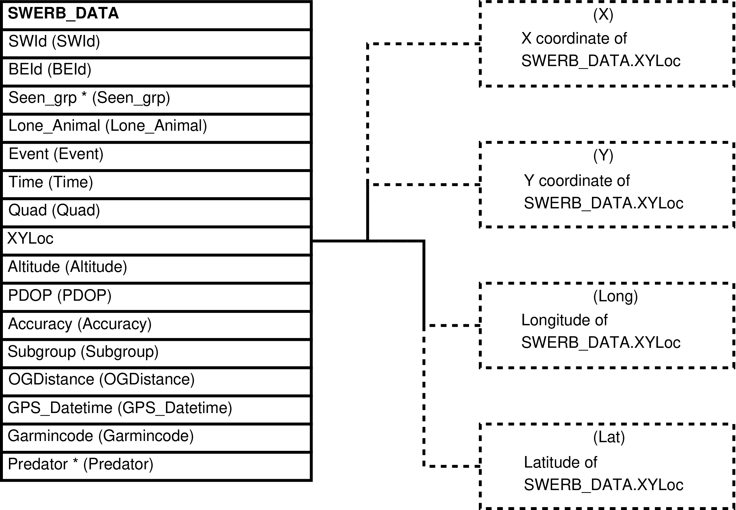
Table 6.75. Columns in the SWERB_DATA_XY View
| Column | From | Description |
|---|---|---|
| SWId | SWERB_DATA.SWId | Identifier of the record of the SWERB event. |
| BEId | SWERB_BES.BEId | Identifier of the bout of uninterrupted observation of the focal group containing observed SWERB event. |
| Seen_grp | SWERB_DATA.Seen_grp | Identifier of the observed group. |
| Lone_Animal | SWERB_DATA.Lone_Animal | Sname of the observed lone male or NULL
when either there is none or an unknown lone male
was observed. |
| Event | SWERB_DATA.Event | Code identifying the kind of SWERB event observed. |
| Time | SWERB_DATA.Time | The time of the observation. |
| Quad | SWERB_DATA.Quad | The code identifying the map quadrant locating the recorded event. |
| X | ST_X(SWERB_DATA.XYLoc) | X coordinate of the XYLoc -- X coordinate of the event. |
| Y | ST_Y(SWERB_DATA.XYLoc) | Y coordinate of the XYLoc -- Y coordinate of the event. |
| Long | ST_X(ST_TRANSFORM(SWERB_DATA.XYLoc, 4326)) | Longitude of the XYLoc -- longitude of the event. |
| Lat | ST_Y(ST_TRANSFORM(SWERB_DATA.XYLoc, 4326)) | Latitude of the XYLoc -- latitude of the event. |
| Altitude | SWERB_DATA.Altitude | The altitude of the SWERB event. |
| PDOP | SWERB_DATA.PDOP | The PDOP of the SWERB event. |
| Accuracy | SWERB_DATA.Accuracy | Accuracy of the SWERB event. |
| Subgroup | SWERB_DATA.Subgroup | Whether or not the SWERB event pertains to a subgroup. |
| OGDistance | SWERB_DATA.Ogdistance | The distance to the non-focal group where the SWERB event takes place. |
| GPS_Datetime | SWERB_DATA.GPS_Datetime | The timestamp, the date and time, automatically recorded by the GPS unit when the waypoint was entered into the GPS. |
| Garmincode | SWERB_DATA.Garmincode | The raw data entered by the observer recording the SWERB event. |
| Predator | SWERB_DATA.Predator | The type of predator seen, or NULL when
there is none. |
Inserting a row into SWERB_DATA_XY inserts a row into SWERB_DATA as expected.
Updating the SWERB_DATA_XY view updates the SWERB_DATA table as expected.
Deleting a row from SWERB_DATA_XY deletes a row from SWERB_DATA as expected.
Contains one row for every row in SWERB_DEPARTS_DATA. Each row contains the SWERB_DEPARTS_DATA data and the related SWERB_DEPARTS_GPS row, excepting the geolocation
data which is converted into X and Y coordinates. In those
cases where there is a SWERB_DEPARTS_DATA
row but not a row from SWERB_DEPARTS_GPS the
columns from SWERB_DEPARTS_GPS are
NULL.
This view is useful when downloading departure data for analysis outside of the database, and useful for deleting all information related to specified departures.
Figure 6.159. Query Defining the SWERB_DEPARTS View
SELECT swerb_departs_data.did AS did

     , swerb_departs_data.date AS date

     , swerb_departs_data.time AS time

     , ST_X(swerb_departs_gps.xyloc) AS x

     , ST_Y(swerb_departs_gps.xyloc) AS y

     , ST_X(ST_TRANSFORM(swerb_departs_gps.xyloc, 4326)) AS long

     , ST_Y(ST_TRANSFORM(swerb_departs_gps.xyloc, 4326)) AS lat

     , swerb_departs_gps.altitude AS altitude

     , swerb_departs_gps.pdop AS pdop

     , swerb_departs_gps.accuracy AS accuracy

     , swerb_departs_gps.gps AS gps

     , swerb_departs_gps.garmincode AS garmincode

  FROM swerb_departs_data

       LEFT OUTER JOIN swerb_departs_gps

                       ON (swerb_departs_gps.did = swerb_departs_data.did)
;
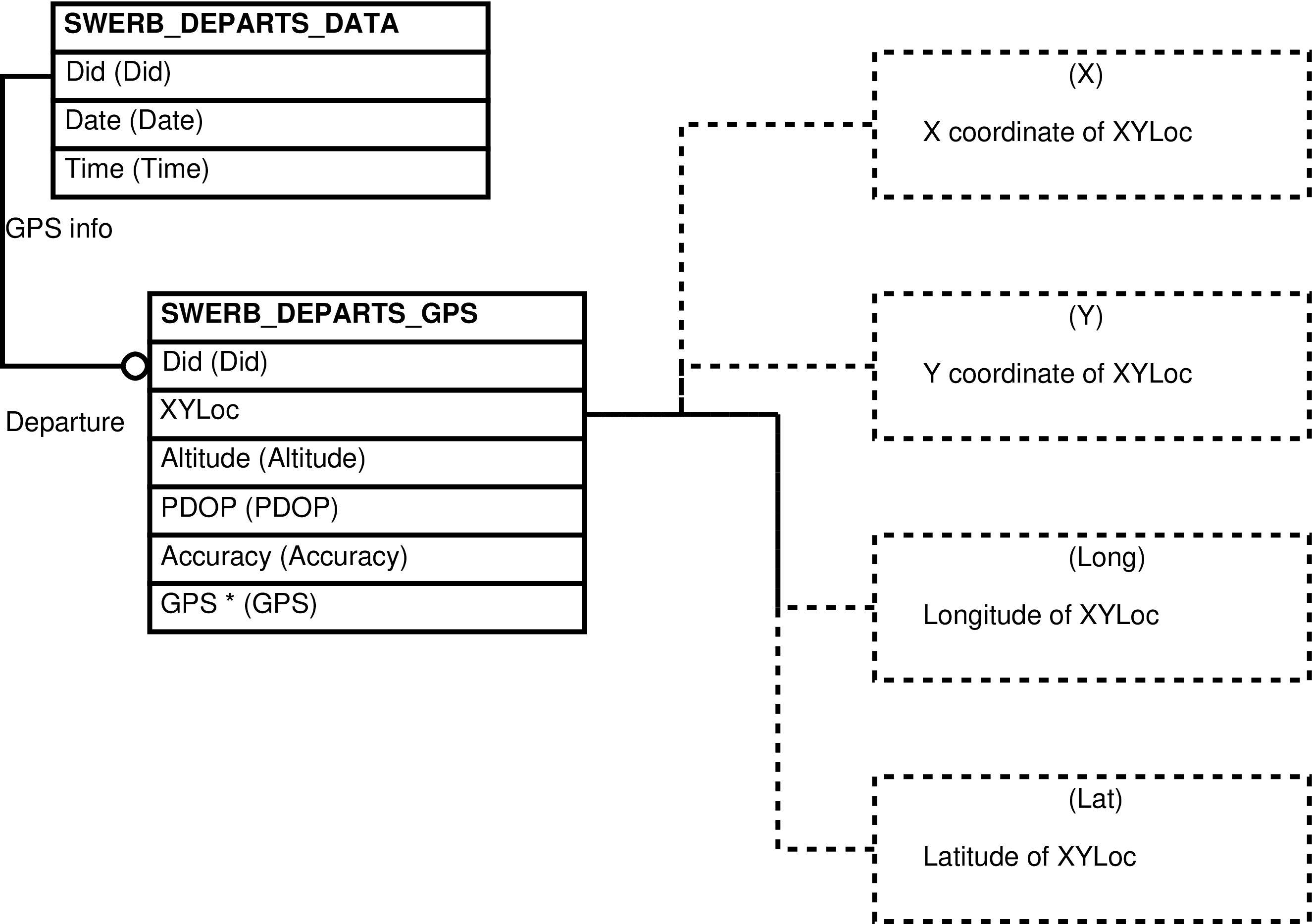
Table 6.76. Columns in the SWERB_DEPARTS View
| Column | From | Description |
|---|---|---|
| Did | SWERB_DEPARTS_DATA.DId | Identifier of the team's departure row. |
| Date | SWERB_DEPARTS_DATA.Date | Date of departure. |
| Time | SWERB_DEPARTS_DATA.Time | Time of the team's departure. |
| X | ST_X(SWERB_DEPARTS_GPS.XYLoc) | X coordinate of the XYLoc -- X coordinate of the point of departure. |
| Y | ST_Y(SWERB_DEPARTS_GPS.XYLoc) | Y coordinate of the XYLoc -- Y coordinate of the point of departure. |
| Long | ST_X(ST_TRANSFORM(SWERB_DEPARTS_GPS.XYLoc, 4326)) | Longitude of the XYLoc -- longitude of the point of departure. |
| Lat | ST_Y(ST_TRANSFORM(SWERB_DEPARTS_GPS.XYLoc, 4326)) | Latitude of the XYLoc -- latitude of the point of departure. |
| Altitude | SWERB_DEPARTS_GPS.Altitude | Altitude at the point of departure. |
| PDOP | SWERB_DEPARTS_GPS.PDOP | Positional Dilution of Precision of the departure's geolocation. |
| Accuracy | SWERB_DEPARTS_GPS.Accuracy | Accuracy of the departure's geolocation expressed as distance in meters. |
| GPS | SWERB_DEPARTS_GPS.GPS | Identifier of the GPS device (GPS_UNITS.GPS) used by the team. |
| Garmincode | SWERB_DEPARTS_GPS.Garmincode | The information manually entered into the waypoint by the observer. |
Inserting a row into SWERB_DEPARTS inserts a row
into SWERB_DEPARTS_DATA and a row into
SWERB_DEPARTS_GPS as expected. Rows are
inserted into SWERB_DEPARTS_GPS when any
of the the relevant columns are present and contain
non-NULL values.
The SWERB_DEPARTS view may be updated and SWERB_DEPARTS_DATA and SWERB_DEPARTS_GPS are (mostly) updated as expected.
Warning
Attempts to update SWERB_DEPARTS_GPS columns when no underlying row exists are silently ignored.
Deleting a row from SWERB_DEPARTS deletes all SWERB data collected by the departing observation team; a row from SWERB_DEPARTS_DATA is deleted along with, if necessary, a row from SWERB_DEPARTS_GPS and multiple related rows from SWERB_OBSERVERS, multiple related rows from SWERB_BES, multiple rows related to these from SWERB_DATA, SWERB_LOC_DATA, and SWERB_LOC_GPS.
Contains one row for every row in SWERB_GW_LOC_DATA.
This view is useful for querying the SWERB_GW_LOC_DATA table because it unifies data that are distributed between the SWERB_GW_LOC_DATA table and the QUAD_DATA table. It is also useful when it is convenient to have X and Y coordinates as separate values instead of geospatial points.
Note
For more information regarding the X and Y coordinates see the description of the columns in the underlying tables, and see the SWERB Data overview.
Figure 6.161. Query Defining the SWERB_GW_LOCS View
SELECT swerb_gw_loc_data.sgwlid AS sgwlid

     , swerb_gw_loc_data.loc AS loc

     , swerb_gw_loc_data.date AS date

     , swerb_gw_loc_data.time AS time

     , swerb_gw_loc_data.quad AS quad

     , CASE

         WHEN swerb_gw_loc_data.xyloc IS NULL

           THEN 'quad'

         ELSE swerb_gw_loc_data.xysource

       END AS xysource

     , COALESCE(ST_X(swerb_gw_loc_data.xyloc), ST_X(quad_data.xyloc))

         AS x

     , COALESCE(ST_Y(swerb_gw_loc_data.xyloc), ST_Y(quad_data.xyloc))

         AS y

     , COALESCE(ST_X(ST_TRANSFORM(swerb_gw_loc_data.xyloc, 4326))

              , ST_X(ST_TRANSFORM(quad_data.xyloc, 4326)))

         AS long

     , COALESCE(ST_Y(ST_TRANSFORM(swerb_gw_loc_data.xyloc, 4326))

              , ST_Y(ST_TRANSFORM(quad_data.xyloc, 4326)))

         AS lat

     , swerb_gw_loc_data.altitude AS altitude

     , swerb_gw_loc_data.pdop AS pdop

     , swerb_gw_loc_data.accuracy AS accuracy

     , swerb_gw_loc_data.gps AS gps

     , swerb_gw_loc_data.notes AS notes

  FROM swerb_gw_loc_data

       LEFT OUTER JOIN quad_data

                       ON (quad_data.quad = swerb_gw_loc_data.quad)
;
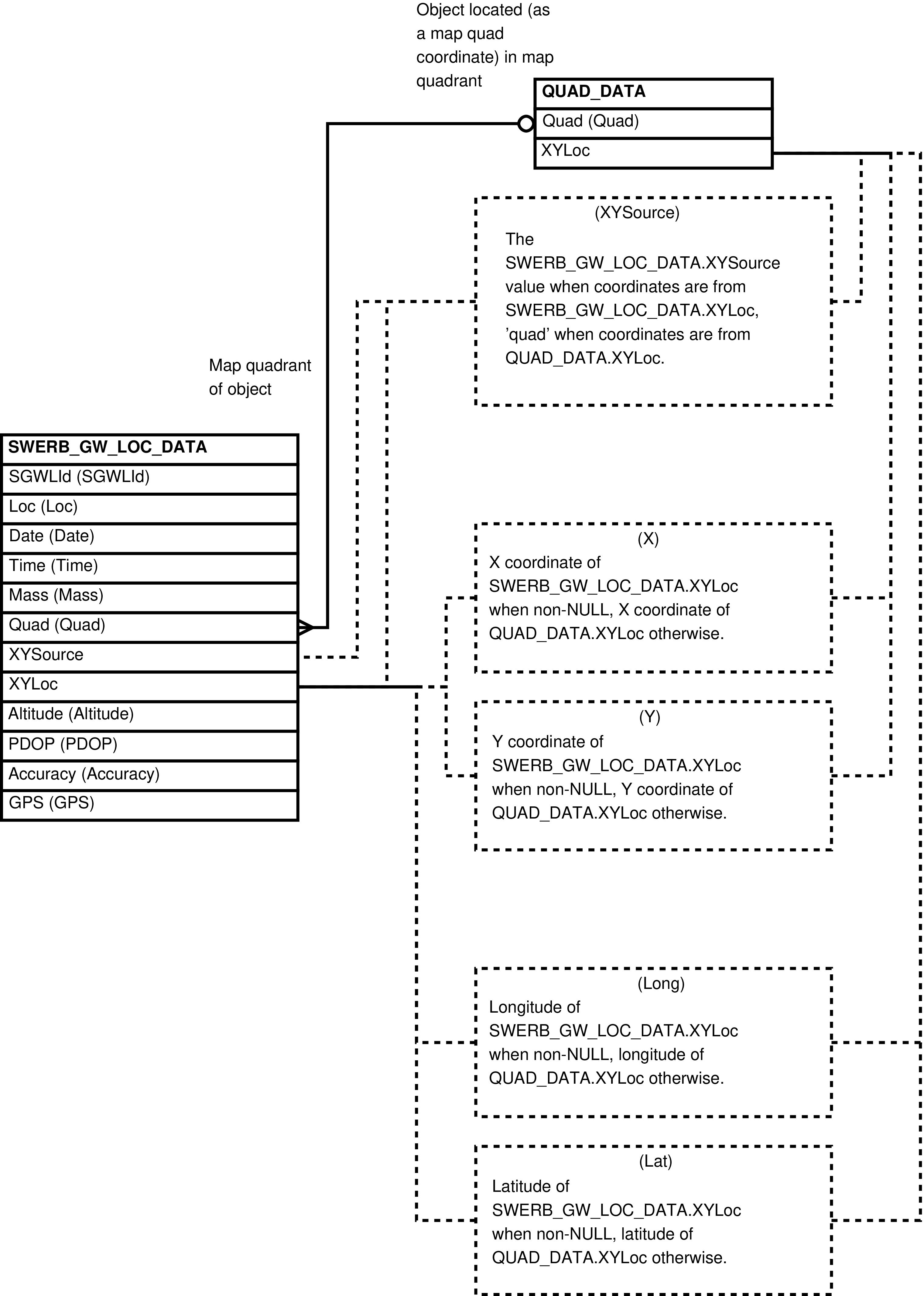
Table 6.77. Columns in the SWERB_GW_LOCS View
| Column | From | Description |
|---|---|---|
| SGWLId | SWERB_GW_LOC_DATA.SGWLId | Identifier of the observation of a grove or waterhole's geolocation. |
| Loc | SWERB_GW_LOC_DATA.Loc | Identifier of the object, the grove or waterhole. |
| Date | SWERB_GW_LOC_DATA.Date | The date of the observation. |
| Time | SWERB_GW_LOC_DATA.Time | The time of the observation. |
| Quad | SWERB_GW_LOC_DATA.Quad | The code identifying the map quadrant containing the grove or waterhole. |
| XYSource |
|
The source of the view's X, Y, Long, and Lat
columns. When quad
the source of those columns are the coordinates of
the centroid of the related map quadrant. Otherwise
this is the value of the SWERB_GW_LOC_DATA.XYSource
column. |
| X | QUAD_DATA.XYLoc or SWERB_GW_LOC_DATA.XYLoc | Whatever X geolocation coordinate exists. |
| Y | QUAD_DATA.XYLoc or SWERB_GW_LOC_DATA.XYLoc | Whatever Y geolocation coordinate exists. |
| Long | ST_X(ST_TRANSFORM(QUAD_DATA.XYLoc or SWERB_GW_LOC_DATA.XYLoc, 4326)) | Whatever longitude coordinate exists. |
| Lat | ST_Y(ST_TRANSFORM(QUAD_DATA.XYLoc or SWERB_GW_LOC_DATA.XYLoc, 4326)) | Whatever latitude coordinate exists. |
| Altitude | SWERB_GW_LOC_DATA.Altitude | The altitude of the object, the grove or waterhole. |
| PDOP | SWERB_GW_LOC_DATA.PDOP | The PDOP of the object's geolocation. |
| Accuracy | SWERB_GW_LOC_DATA.Accuracy | Accuracy of the object's geolocation. |
| GPS | SWERB_GW_LOC_DATA.GPS | Identifier of the GPS unit (GPS_UNITS) used to take the measurement. |
| Notes | SWERB_GW_LOC_DATA.Notes | Notes on the measurement. |
Contains one row for every row in SWERB_GW_LOC_DATA.
This view is useful when it is convenient to have X and Y coordinates as separate values instead of geospatial points. For this reason is it also useful when maintaining the SWERB_GW_LOC_DATA table. Users querying the view may prefer the SWERB_GW_LOCS view.
Figure 6.163. Query Defining the SWERB_GW_LOC_DATA_XY View
SELECT swerb_gw_loc_data.sgwlid AS sgwlid

     , swerb_gw_loc_data.loc AS loc

     , swerb_gw_loc_data.date AS date

     , swerb_gw_loc_data.time AS time

     , swerb_gw_loc_data.quad AS quad

     , swerb_gw_loc_data.xysource AS xysource

     , ST_X(swerb_gw_loc_data.xyloc) AS x

     , ST_Y(swerb_gw_loc_data.xyloc) AS y

     , ST_X(ST_TRANSFORM(swerb_gw_loc_data.xyloc, 4326)) AS long

     , ST_Y(ST_TRANSFORM(swerb_gw_loc_data.xyloc, 4326)) AS lat

     , swerb_gw_loc_data.altitude AS altitude

     , swerb_gw_loc_data.pdop AS pdop

     , swerb_gw_loc_data.accuracy AS accuracy

     , swerb_gw_loc_data.gps AS gps

     , swerb_gw_loc_data.notes AS notes

  FROM swerb_gw_loc_data
;
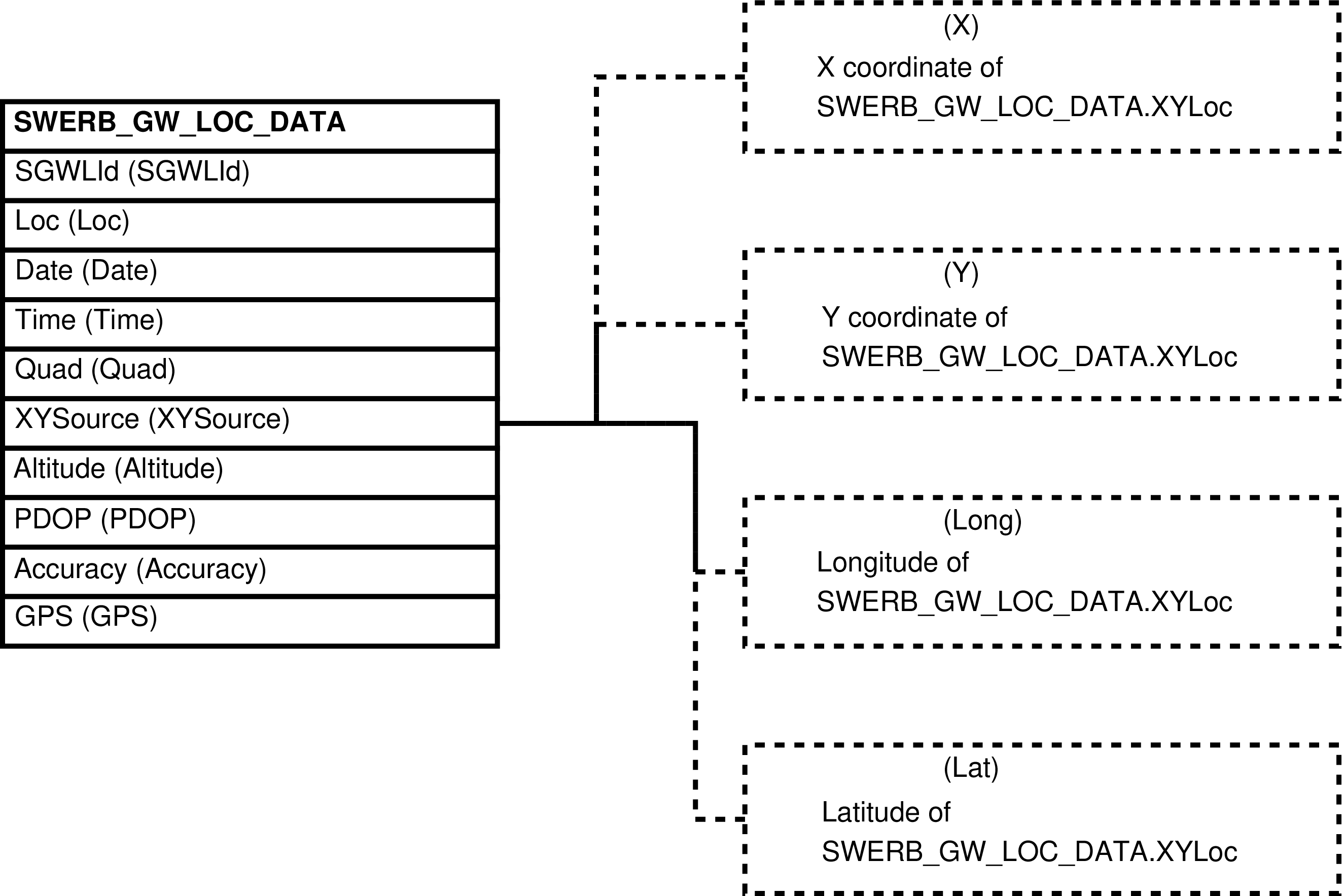
Table 6.78. Columns in the SWERB_GW_LOC_DATA_XY View
| Column | From | Description |
|---|---|---|
| SGWLId | SWERB_GW_LOC_DATA.SGWLId | Identifier of the observation that geolocated the object, the grove or waterhole. |
| Loc | SWERB_GW_LOC_DATA.Loc | Identifier of the object, the grove or waterhole, that is located. |
| Date | SWERB_GW_LOC_DATA.Date | The date of the observation. |
| Time | SWERB_GW_LOC_DATA.Time | The time of the observation. |
| Quad | SWERB_GW_LOC_DATA.Quad | The code identifying the map quadrant containing the observed object, the grove or waterhole. |
| X | ST_X(SWERB_GW_LOC_DATA.XYLoc) | X coordinate of the XYLoc -- X coordinate of the object. |
| Y | ST_Y(SWERB_GW_LOC_DATA.XYLoc) | Y coordinate of the XYLoc -- Y coordinate of the object. |
| Long | ST_X(ST_TRANSFORM(SWERB_GW_LOC_DATA.XYLoc, 4326)) | Longitude of the XYLoc -- longitude of the object. |
| Lat | ST_Y(ST_TRANSFORM(SWERB_GW_LOC_DATA.XYLoc, 4326)) | Latitude of the XYLoc -- latitude of the object. |
| Altitude | SWERB_GW_LOC_DATA.Altitude | The altitude of the object. |
| PDOP | SWERB_GW_LOC_DATA.PDOP | The PDOP of the geolocation. |
| Accuracy | SWERB_GW_LOC_DATA.Accuracy | Accuracy of the SWERB geolocation. |
| GPS | SWERB_GW_LOC_DATA.GPS | The code identifying the GPS unit (GPS_UNITS) used to take the observation. |
| Notes | SWERB_GW_LOC_DATA. Notes | Notes on the observation. |
Inserting a row into SWERB_GW_LOC_DATA_XY inserts a row into SWERB_GW_LOC_DATA as expected.
Updating the SWERB_GW_LOC_DATA_XY view updates the SWERB_GW_LOC_DATA table as expected.
Deleting a row from SWERB_GW_LOC_DATA_XY deletes a row from SWERB_GW_LOC_DATA as expected.
Contains one row for every row in SWERB_LOC_GPS.
This view is useful when it is convenient to have X and Y coordinates as separate values instead of geospatial points. For this reason is it also useful when querying and maintaining the SWERB_LOC_GPS table.
Figure 6.165. Query Defining the SWERB_LOC_GPS_XY View
SELECT swerb_loc_gps.swid AS swid

     , ST_X(swerb_loc_gps.xyloc) AS x

     , ST_Y(swerb_loc_gps.xyloc) AS y

     , ST_X(ST_TRANSFORM(swerb_loc_gps.xyloc, 4326)) AS long

     , ST_Y(ST_TRANSFORM(swerb_loc_gps.xyloc, 4326)) AS lat

     , swerb_loc_gps.altitude AS altitude

     , swerb_loc_gps.pdop AS pdop

     , swerb_loc_gps.accuracy AS accuracy

     , swerb_loc_gps.gps_datetime AS gps_datetime

     , swerb_loc_gps.garmincode AS garmincode

  FROM swerb_loc_gps
;
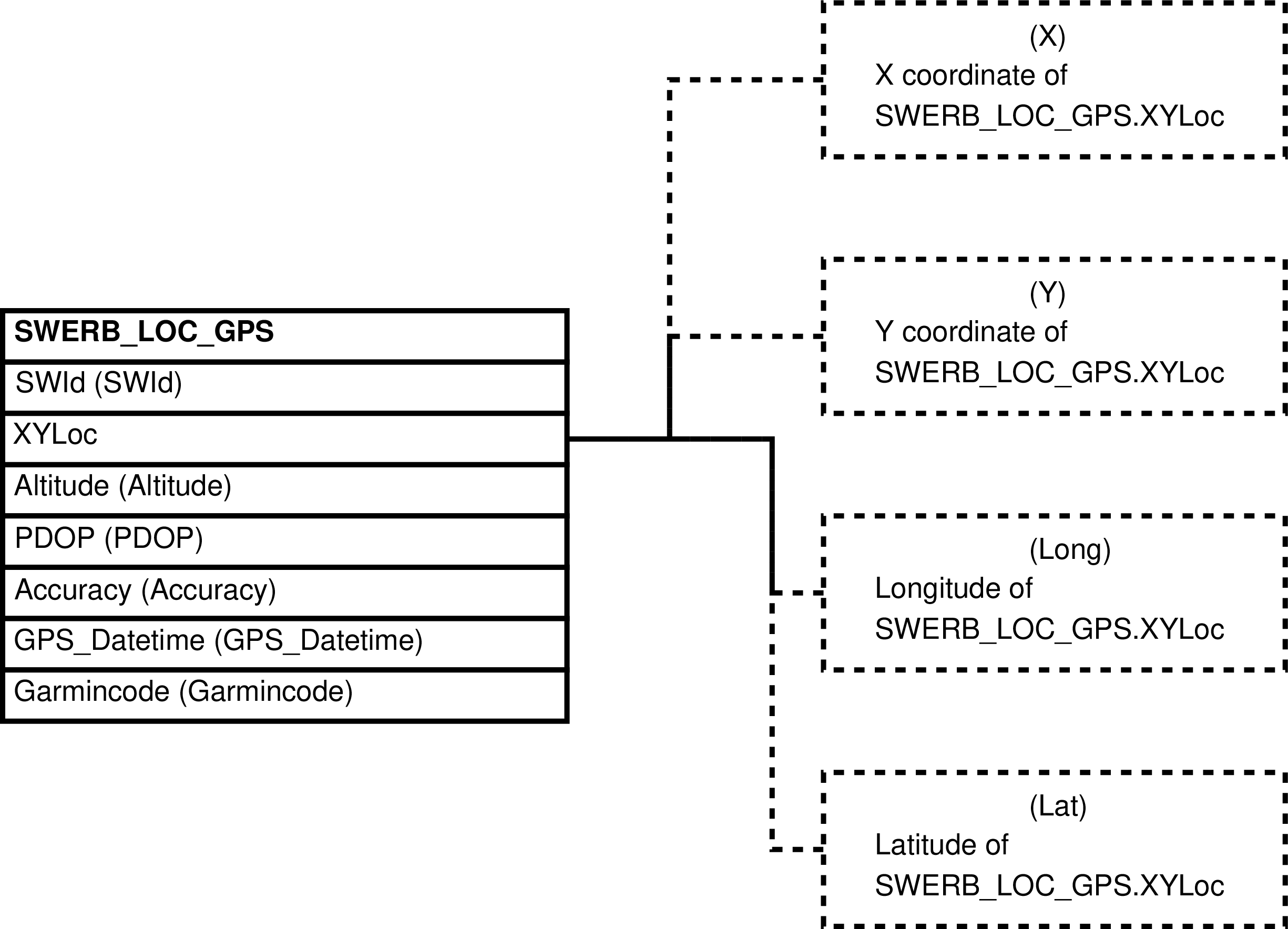
Table 6.79. Columns in the SWERB_LOC_GPS_XY View
| Column | From | Description |
|---|---|---|
| SWId | SWERB_LOC_GPS.SWId | Identifier of the GPS information involving an observation of a group at a particular time at a particular grove or waterhole. Also the SWERB_DATA.SWId value and the SWERB_LOC_DATA.SWId value |
| X | ST_X(SWERB_LOC_GPS.XYLoc) | X coordinate of the XYLoc -- X coordinate of the group. |
| Y | ST_Y(SWERB_LOC_GPS.XYLoc) | Y coordinate of the XYLoc -- Y coordinate of the group. |
| Long | ST_X(ST_TRANSFORM(SWERB_LOC_GPS.XYLoc, 4326)) | Longitude of the XYLoc -- Longitude of the group. |
| Lat | ST_Y(ST_TRANSFORM(SWERB_LOC_GPS.XYLoc, 4326)) | Latitude of the XYLoc -- latitude of the group. |
| Altitude | SWERB_LOC_GPS.Altitude | The altitude of the group. |
| PDOP | SWERB_LOC_GPS.PDOP | The PDOP of the geolocation. |
| Accuracy | SWERB_LOC_GPS.Accuracy | Accuracy of the SWERB geolocation. |
| GPS_Datetime | SWERB_LOC_GPS.GPS_Datetime | The date and time recorded by the GPS unit. |
| Garmincode | SWERB_LOC_GPS. Garmincode | The information manually entered into the waypoint by the observer. |
Inserting a row into SWERB_LOC_GPS_XY inserts a row into SWERB_LOC_GPS as expected.
Updating the SWERB_LOC_GPS_XY view updates the SWERB_LOC_GPS table as expected.
Deleting a row from SWERB_LOC_GPS_XY deletes a row from SWERB_LOC_GPS as expected.
Contains one row for every row in SWERB_LOC_DATA.
This view is useful for querying the SWERB_LOC_DATA table because makes explicit whether or not the landscape feature involves descent from or ascent into a sleeping grove.
Figure 6.167. Query Defining the SWERB_LOCS View
SELECT swerb_loc_data.swid AS swid

     , swerb_loc_data.loc AS loc

     , swerb_loc_data.adcode AS adcode

     , adcodes.adn AS adn

     , swerb_loc_data.loc_status AS loc_status

     , swerb_loc_data.adtime AS time

  FROM swerb_loc_data

       JOIN adcodes ON (adcodes.adcode = swerb_loc_data.adcode)
;
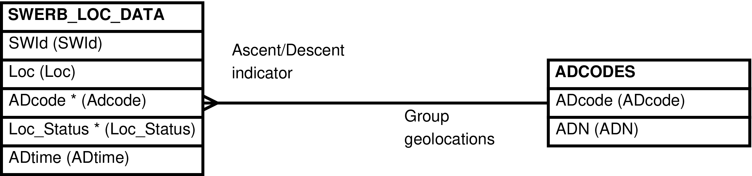
Table 6.80. Columns in the SWERB_LOCS View
| Column | From | Description |
|---|---|---|
| SWId | SWERB_LOC_DATA.SWId | Identifier of the placement of the group at the landscape feature and of the related of the SWERB event, the SWERB_DATA.SWId. |
| Loc | SWERB_LOC_DATA.Loc | Identifier of the related landscape feature, the SWERB_GWS.Loc. |
| ADcode | SWERB_LOC_DATA.ADcode | The code denoting the relationship between the group and the landscape feature. |
| ADN | ADCODES.ADN | Whether the relationship between the group
and the landscape feature is an ascent into a
sleeping grove
(A), a descent
from a sleeping grove
(D), or neither
(N). |
| Loc_Status | SWERB_LOC_DATA.Loc_Status | Code representing the status of the team's observation of the indicated landscape feature. |
| ADtime | SWERB_LOC_DATA.ADtime | Median time of group descent from or ascent into the sleeping grove. |
This view returns no rows, it is used only to upload
data into the SWERB portion of Babase. Attempting to
SELECT rows from this view will raise an
error.
This view exists instead of a custom upload program.
The SWERB_UPLOAD view uses
G as the value for SWERB_BES.Bsource and
SWERB_BES.Esource in the SWERB_BES rows it inserts, unless a different
value is provided in this view's Source column.
Whenever the SWERB_UPLOAD view obtains a SWERB_DATA.Time from the GPS unit (the SWERB_DATA.GPS_Datetime value) instead of from operator entry (the SWERB_DATA.Garmincode value) the seconds portion of the timestamp is discarded.
When a median ascent/descent time is entered into the
GPS unit by the observer the SWERB_UPLOAD program uses the
values A and
D for the ascent and
descent SWERB_LOC_DATA.ADcode value,
respectively.[283] When a drinking event is recorded the SWERB_UPLOAD
view uses the value N
for the SWERB_LOC_DATA.ADcode. (See ADCODES: Special Values.)
When SWERB_UPLOAD
encounters a line which records a drinking event and the
immediately preceding line (or pair of lines in the case of
beginning of observation) is an observation of a subgroup and
the line immediately following (or pair of lines in the case
of end of observation) is an observation of a subgroup then
the SWERB_DATA.Subgroup of the drinking event will be
set to TRUE -- the drinking event will be recorded as that
of a subgroup.[284] When considering whether the preceding and
subsequent lines are of subgroups lines representing drinking
events and lines representing observations of lone animals and
other groups are ignored.
When SWERB_UPLOAD encounters a non-focal group
observation that is not part of any bout of observation it
automatically creates a bout of observation to contain the
non-focal group observation. The created bout of observation
has as its focal the unknown group
(9.0). It begins and ends at the
time of the non-focal group observation and so has a duration
of 0 minutes. It is also marked as a bout of observation
which should not count toward observer effort (SWERB_BES.Is_Effort is
FALSE). Aside from the begin and end rows, the only SWERB
observation (the only SWERB_DATA) row
belonging to the bout is the non-focal group
observation.
The format of the data that is inserted into the SWERB_UPLOAD view is complex. This section provides an overview and remarks on unusual features[285] and the tasks required of the data entry manager to convert the raw SWERB data into an uploadable format. The description of the SWERB_UPLOAD view in the following sections describes how the various uploaded columns map into the columns of Babase's tables. Because, excepting variances described in this section, the uploaded data comes directly from the GPS units used to collect SWERB data the reader should rely on the description of the SWERB data collection protocol in the Amboseli Baboon Research Project Monitoring Guide for a complete description of the data format.[286]
Each upload into the SWERB_UPLOAD view must consist of the data collected on a single GPS unit by a single observation team during the course of a single day.
The data is uploaded as a collection of lines containing tab-delimited text. Each line represents a waypoint recorded by the operator. The lines are expected to be in chronological order, the first line being the first waypoint recorded and the last line being the last, with the exceptions that the lines contriving any one bout of observation of any one (sub)group must be contiguous and that the begin and end lines which record the sleeping grove must immediately precede the begin and end lines which record the descent or ascent time.[287] Consequently the following constraints are imposed on the data: the first line(s) must record the observation team's departure from camp; the lines representing a bout of observation must be contiguous; the line denoting the beginning of a bout of observation must precede all of the bout's other lines; the line denoting the end of a bout of observation must follow all of the bout's other lines; the line recording the median descent time, when present, must immediately follow the line denoting beginning of the bout of observation and the previous night's sleeping grove; the line recording the median ascent time, when present, must immediately follow the line denoting end of the bout of observation and the night's sleeping grove; in those cases where a group utilizes more than one sleeping grove the sleeping grove information must consist of contiguous pairs of lines (as just described) with no intervening lines of another sort; notwithstanding anything to the contrary above, lines denoting observations of the non-focal group may appear at any point after the lines representing departure from camp.[288]
Note
When there is more than one line representing departure of the team from camp the only GPS information recorded in SWERB_DEPARTS_GPS is that of the first departure line. The GPS information (XY coordinates, altitude, pdop, timestamp, etc.) recorded in successive departure rows is discarded; successive departure lines serve only to supply additional observers and their roles for insertion into the SWERB_OBSERVERS table.
The first 2 lines of the uploaded file are required to
be departure lines, lines which record information about the
departing observation team. The first line must begin with
a D, it lists the
observers. The initials supplied on this first line control
the SWERB_OBSERVERS.Role value used, the value used
being the referenced OBSERVERS.SWERB_Observer_Role column's value.
The second line must begin with
DD,
it lists the drivers. The initials supplied on the second
line control the SWERB_OBSERVERS.Role value used, the value used
being the referenced OBSERVERS.SWERB_Driver_Role column's
value.
It is an error if all the lines representing departure from camp indicate the use of more than one GPS unit. Each data upload into SWERB_DEPARTS must come from a single GPS unit.
It is an error if observer codes cannot be unambiguously interpreted in the departure lines. This means that when there is an observer code which is shorter and match in its entirety the beginning of other observer codes then none of these observer codes, neither the shorter nor the longer, can be reliably used in SWERB departure waypoints.[289] If there is ambiguity the offending observer code must be manually removed from the departure line and manually inserted into SWERB_OBSERVERS after uploading the data file.
When the field team records coordinates for the start or stop of a bout of observation but somehow fails to record the time, then that time must be estimated by the data entry staff and included in the Description. In this case the columns Timeest and Source must be added to the data file by the data manager. The data manager should supply values for these columns only in the begin and end lines.
Note
The SWERB_LOC_DATA.ADcode value is sometimes
obtained directly from the GPS waypoint data (the Name
column) entered by the observer, from the second begin/end
line recording median ascent/descent time. This occurs
when, for whatever reason, the operator does not record a
time following after entering the letters
MAT or
MAT. Whatever is entered in
place of a time (which is required to be entered as
4 digits), is used for the SWERB_LOC_DATA.ADcode value.
When the field team fails to record the start or stop
of a bout of observation at all, the data manager needs to
create one. In these cases, coordinates cannot be
estimated, but the start/stop time may be known or estimated
from other data. However, when a date and time are provided
(when Description is not
NULL), it is normally a rule that coordinates must also be
provided (Position cannot be
NULL). To manage this conflict, the boolean column BE_Has_Coords is used. When
FALSE, the Position must be
NULL and the Description is
allowed to be non-NULL[290]. When BE_Has_Coords is TRUE or NULL
and the Description is not
NULL, the Position cannot
be NULL, as usual.
The BE_Has_Coords
column is only used for begins and ends of observation
bouts. This column must be NULL for all other rows.
The data collection protocols require that each observation team record ascent and descent times and groves for their first and last observations of each group for the day. When more than one observation team observes a single group on a given day then the data manager must choose which observation team's ascent/descent information is to be used.[291]The unused ascent and descent information must be removed from the uploaded data. This requires removing the grove from the end of the waypoint text, in the Name column, and deleting the line denoting median descent/ascent time. This should leave a single beginning of observation/end of observation line in the place within the file from which the sleeping grove ascent/descent information has been purged.
The SWERB_UPLOAD view treats a leading
P character before
grove codes written into the uploaded begin and end lines as
an indication that the sleeping grove is probable (SWERB_LOC_DATA.Loc_Status is
P) unless the result of
removing the leading
P produces a code
which is not in SWERB_GWS as a grove. In
this case the leading
P is considered
part of the grove code.
Although the field operators enter information after
the B and E codes in
those waypoints recording the beginning and ending of bouts
of observation that do not denote
descent from or ascent into sleeping groves, the
SWERB_UPLOAD view is unable to process this additional
information. The data manager must remove this information
from those begin and end lines that occur when observation
of the focal group is interrupted for some reason.
When the field team records secondary ascents or
descents, when there are subgroups and more than one begin
or end is recorded for the group, the data managers must add
additional lines to the uploaded data to convert these
“extra” begins or ends into independent bouts
of observation[292]. All of these lines, the original secondary
ascent or descent lines and the additional lines added by
the data manager, must be marked with a TRUE value in a
Secondary_AD column. (This
column will also have to be added by the data
manager.)
The bout of observation created for the secondary ascent or descent must consist only of begin and end rows, no other kinds of observation are allowed. The SWERB_UPLOAD view will generate an error if other kinds of observations are interspersed between the begin and end rows of a secondary ascent or descent.[293]
Secondary ascents and descents must occur during a
regular bout of observation -- uploaded rows with a TRUE
Secondary_AD value must be
preceded by non-secondary begin rows and followed by
non-secondary end rows.
Caution
Although row-wise ordering of secondary bouts of observation is enforced by SWERB_UPLOAD there is no enforcement of time-wise ordering.
Lone animal sightings must be flagged as such in the SWERB_UPLOAD.Lone_Animal column. The sex of the individual must match the sex indicated in the SWERB_UPLOAD.Lone_Animal column.
The SWERB_UPLOAD view looks up the the sname for lone
animal entered as part of the garmincode in the Unksname column of the UNKSNAMES table. If found and the related UNKSNAMES.Lonemale
value is M the sname of the lone
male is stored in SWERB_DATA.Lone_Animal as a NULL.
Note
As usual not all columns need be present in the uploaded data file and, while the column headings are significant, the order of the columns is not. In particular it is expected that older data using the quad coordinate system will use the Quad column in place of the Position column.
Note
Many columns are may be included in the uploaded data but are ignored. This is to reduce the amount of data manipulation which the data manager must perform on the raw data downloaded from the GPS units.
It is an error to include values in both the Description and the Date columns on the same line.
The geographic coordinates for each row are recorded
in the Position column. As
discussed elsewhere, the provided
coordinates may use WGS
1984 UTM Zone 37South coordinates or longitude and
latitude via the WGS
1984 2D CRS, but the location will be
stored in its respective table as a WGS
1984 UTM Zone 37South location. When
a coordinate in longitude or latitude converts to a UTM
coordinate with too many digits after the decimal, the
converted value is rounded to the nearest
0.1.
Because the coordinates in the Position column may be from either system, this view uses the provided Position to guess which system is being used. When the provided value begins with 37 M, the coordinates are assumed to be from the WGS 1984 UTM Zone 37South system. The expected format of those data is “37 M” space [X-coordinate] space [Y-coordinate]. The XY units are in meters and are always positive. When the provided value begins with 37., the coordinates are presumed to be from the WGS 1984 2D CRS. The expected format of those data is [longitude] space [latitude]. The units are decimal degrees, with a positive longitude and a negative latitude.
Figure 6.169. Query Defining the SWERB_UPLOAD View
SELECT NULL::TEXT AS header

     , NULL::TEXT    AS name

     , NULL::TEXT    AS description

     , NULL::TEXT    AS type

     , NULL::TEXT    AS position

     , NULL::TEXT    AS altitude

     , NULL::TEXT    AS depth

     , NULL::TEXT    AS proximity

     , NULL::TEXT    AS display_mode

     , NULL::TEXT    AS color

     , NULL::TEXT    AS symbol

     , NULL::TEXT    AS facility

     , NULL::TEXT    AS city

     , NULL::TEXT    AS state

     , NULL::TEXT    AS country

     , NULL::TEXT    AS pdop

     , NULL::TEXT    AS accuracy

     , NULL::TEXT    AS quad

     , NULL::TEXT    AS date

     , NULL::TEXT    AS timeest

     , NULL::TEXT    AS source

     , NULL::TEXT    AS lone_animal

     , NULL::TEXT    AS is_effort

     , NULL::BOOLEAN AS secondary_ad

     , NULL::BOOLEAN AS be_has_coords

     , NULL::TEXT    AS notes

  WHERE _raise_babase_exception(

          'Cannot select SWERB_UPLOAD'

          || ': The only use of the SWERB_UPLOAD view is to insert'

          || ' new data into the SWERB portion of babase')
;
Figure 6.170. Entity Relationship Diagram of the SWERB_UPLOAD View
Table 6.81. Columns in the SWERB_UPLOAD View
| Column | Uploads into | Description |
|---|---|---|
| Header | Data in this column is not inserted into Babase. | A record of which button was pushed on the
GPS unit. It is an error if this value is not
either NULL, as would be the case when the column is
omitted from the uploaded data, or
Waypoint. |
| Name | One or more columns of one or more of SWERB_DEPARTS_DATA, SWERB_DEPARTS_GPS, SWERB_BES, SWERB_DATA, and SWERB_LOC_DATA | The data entered by the field operator when recording the waypoint. The entered text not only supplies data but also drives which tables and columns receive the line's data. See above and the Amboseli Baboon Research Project Monitoring Guide. |
| Description | SWERB_DATA.GPS_Datetime and sometimes also SWERB_DATA.Time, or SWERB_DEPARTS_DATA.Date and SWERB_DEPARTS_DATA. Time, or ignored | This is the timestamp, date and time,
the GPS unit automatically supplies when the
waypoint is taken. With a few exceptions —
camp departure rows, median ascent or descent time
rows, and observations begins or ends whose BE_Has_Coords is If this column is blank ('') or The format of this data is “yyyy/mm/dd space HH:MM”. |
| Type | Ignored | The GPS unit supplies more information about the pressed button in this column. This information is ignored. |
| Position | SWERB_DEPARTS_GPS.XYLoc or SWERB_DATA.XYLoc or ignored | The geolocation coordinates supplied by the GPS unit. In the case of the first of those lines representing departure from camp this is the place of departure. In most of the remainder of this lines this is the location where the data waypoint was taken. See above for when this information is discarded. Also see above for how the system determines which coordinate system is being used. |
| Altitude | SWERB_DEPARTS_GPS.Altitude or SWERB_DATA.Altitude or ignored | The altitude supplied by the GPS unit. In the case of the first of those lines representing departure from camp this is the altitude of the place of departure. In most of the remainder of this lines this is the altitude where the data waypoint was taken. See above for when this information is discarded. The format of this data is numeric, possibly followed by a space and then either the characters “ft” or the character “m”. This value is in meters, unless the characters “ft” are present in which case the value is in feet. The SWERB_UPLOAD view converts feet to meters for storage in the database by multiplying by 0.3048. |
| Depth | Ignored | This information is ignored. |
| Proximity | Ignored | This information is ignored. |
| Display_Mode | Ignored | This information is ignored. |
| Color | Ignored | This information is ignored. |
| Symbol | Ignored | This information is ignored. |
| Facility | Ignored | This information is ignored. |
| City | Ignored | This information is ignored. |
| State | Ignored | This information is ignored. |
| Country | Ignored | This information is ignored. |
| Pdop | SWERB_DEPARTS_GPS.PDOP or SWERB_DATA.PDOP or ignored | The PDOP supplied by the GPS unit. In the case of the first of those lines representing departure from camp this is the PDOP of the departure reading. In most of the remainder of this lines this is the PDOP of the geolocation reading where the data waypoint was taken. See above for when this information is discarded. The format of this data is numeric. |
| Accuracy | SWERB_DEPARTS_GPS.Accuracy or SWERB_DATA.Accuracy or ignored | The accuracy supplied by the GPS unit. In the case of the first of those lines representing departure from camp this is the accuracy of the departure reading. In most of the remainder of this lines this is the accuracy of the geolocation reading where the data waypoint was taken. See above for when this information is discarded. The format of this data is numeric. The units are meters. |
| Quad | SWERB_DATA.Quad or ignored | The quad coordinates of the SWERB waypoint reading. It is an error to supply a quad value for departure lines or for the 2nd begin or end lines. In most of the remainder of this lines this is the location where the data waypoint was taken. See above for when this information is discarded. This data must be a valid QUADS.Quad value. |
| Date | Ignored or SWERB_DEPARTS_DATA.Date | The date of manually recorded SWERB data, data collected before GPS units were put in service. In the case of departure lines this is the departure date. Data supplied manually by the data manager in order that uploaded data conform to the required rules, as when the field team accidentally omits a begin or end record, may use a value on the Date column in lieu of data values in all the columns automatically supplied by the GPS units. In all other lines the value of this column is ignored. The date may be in any format accepted by PostgreSQL. |
| Timeest | Ignored or SWERB_BES.Btimeest or SWERB_BES.Etimeest | Whether the begin or end line was entered by
the data manager and contains an estimated time.
The column must contain no value for those lines
that represent something other than the beginning or
end of a bout of observation. Since the begin/end
time is from the first of the 2 (if 2 are present)
begin/end lines only the first begin and end line
can have an estimated time. The format is any
boolean representation recognized by PostgreSQL.
The empty string, an omitted value, is taken to be
FALSE.
|
| Source | Ignored or SWERB_BES.Bsource or SWERB_BES.Esource | How the data manager obtained the begin or
end time. This must be a SWERB_TIME_SOURCES.Source value, or
blank. This column must contain no value (the empty
string or NULL) for those lines that represent
something other than the beginning or end of a bout
of observation. Since the the begin/end time is
obtained from the first of the 2 (if 2 are present)
begin/end lines only the first begin and end line
can have a source value. The default value, when
the empty string or NULL, is
G. |
| Lone_Animal | Nowhere; controls interpretation of the row | A legal BIOGRAPH.Sex value. When non-NULL and
not empty the row represents a lone animal sighting
and is interpreted as such. When NULL or empty
the row is not a lone animal sighting. |
| Is_Effort | SWERB_BES.Is_Effort | Must be NULL or the empty string unless the
line represents the start of a bout of observation,
and is the first start line when there are more than
one. Whether the bout of observation is to be
counted toward total observer effort. Defaults to
FALSE when not supplied with the first line
representing the beginning of a bout of
observation.[a] |
| Secondary_AD | Nowhere; controls interpretation of the row | A boolean value. All PostgreSQL boolean
representations are accepted. When TRUE the row
represents a secondary ascent or descent, presumably
of a subgroup, and a separate bout of observation
will be created. When FALSE or NULL the row is
not part of a secondary ascent or descent
observation. |
| BE_Has_Coords | Nowhere; controls interpretation of the row | A boolean value. All PostgreSQL boolean
representations are accepted. When FALSE the row
represents a start or stop of observation that was
not recorded in a GPS unit but whose time was
nontheless estimated from other available data.
This is the only case where a Description can be provided
while the Position is
NULL. When TRUE or NULL, the row is not one
of these unusual starts/stops. |
| Notes | SWERB_BES.Notes | Must be NULL or the empty string unless the
line is the first line representing the start of a
bout of observation. Any notes regarding the bout
of observation. Replaces any existing value.
Defaults to NULL and is changed to NULL when the
empty string. |
|
[a] Lines representing sightings of "other"
(non-focal) groups and lone individuals are not
interpreted as lines beginning observation bouts,
even though these events are recorded in SWERB_BES as independent bouts of
observation. Because of this, an Is_Effort value
cannot be supplied for these events, and therefore
will default to |
||
[283] Because sleeping grove information is entered into the
GPS units as 2 separate waypoints, which spreads the
sleeping grove information over two lines of uploaded data,
the A and
D codes are always
used when the SWERB_LOC_DATA row is
created by the SWERB_UPLOAD view. The
SWERB_LOC_DATA.ADcode value is then updated to
the correct value when the 2nd SWERB waypoint is
processed.
The alternative to this temporary use of the
A and
D codes is to allow
the SWERB_LOC_DATA.ADcode to be NULL until the
transaction is committed, and to defer
related checks until transaction commit.
[284] This is due to the 10 character data entry limit in the GPS units. The entry of an S character when recording drinking events would cause the 10 character limit to be exceeded (when the waterhole codes are 4 characters, as they often are) so the SWERB_UPLOAD view uses this method to guess whether a subgroup was observed.
[285] Unusual to those familiar with the data collection protocol. We don't mention things that might be surprising to the casual observer.
[286] This is not ideal. Or rather, the approach is sound but the practice deficient. The Amboseli Baboon Research Project Monitoring Guide's description of the waypoint text entered by the operator could use some work.
[287] The only time this is an issue is when a team is observing more than one group at one time. In this case manual intervention on the part of the data manager is also required to avoid double counting observer effort. See the Is_Effort column.
[288] The SWERB_UPLOAD view does not actively test for these conditions, it assumes that they exist. In the normal course of events it is unlikely, but possible, to insert invalid data into SWERB when these conditions are violated.
[289] It is possible to improve the algorithm used to better discern valid observer codes. This would reduce the need for manual intervention on the part of the data manager at the cost of increased complexity in the code.
[290] In this case, it is assumed but not required that the data manager will also make good use of the Timeest and Source columns.
[291] Or at least this is the ideal. In actual practice it is difficult for the data managers to know when a group has been observed by more than one team on any given day.
[292] Bouts of observation of zero-length, although the system does not require this. Note that the Is_Effort column may be of interest in these cases.
[293] Note that the rule which requires a strict time-wise ordering of the uploaded rows does not apply to the begin and end rows marked as secondary ascents and descents. This allows the creation of secondary ascent and descent bouts which are of non-zero length, should such need to exist.